
Witness to History
“We may live to see air-ships a common sight, but habit has not dulled the edge of wonder, and I wish that the reader could have witnessed the actual spectacle. "It looked like a miracle," said one who saw it, and the photograph, though taken from the original, conveys but imperfectly the impression given by the flight itself.” - Samuel Pierpont Langley, 1897
On May 6, 1896, Samuel Pierpont Langley achieved the world’s first engine-driven heavier-than-air flight of a craft of substantial size with the launch of Aerodrome No. 5 from atop a houseboat moored at Chopawamic Island in Stafford County, Virginia. The flight was observed and photographed by Alexander Graham Bell, the Scottish-born scientist, engineer, and inventor of the telephone and by Frederick E. Fowle, Jr., a junior assistant at the Smithsonian Astrophysical Observatory. The purpose of this analysis is to interpret and reconcile these photographs with firsthand accounts of this remarkable human achievement.
Exhibit A - Path of Aerodrome Flights, from Langley Memoir of Mechanical Flight, Plate 19.
Firsthand Account
Langley provided the following account of the May 6, 1896 flight of Aerodrome No. 5 in Langley Memoir of Mechanical Flight, published in 1911:
“The condition of No. 5, which made the first successful flight, is given in the data sheet for May 6, 1896, and its general form at this time may be seen in the photograph of May 11, Plate 27A. Although the changes described above, as well as the modifications in the boilers and burners of both aerodromes had undoubtedly effected a great improvement in every detail of the machines, the disappointments experienced in the preceding years prevented any great feeling of confidence that the trials which were now to be made would be entirely successful. On May 4, however, the two mechanics, Mr. Reed and Mr. Maltby, were sent down to Quantico with Aerodromes Nos. 5 and 6, and Mr. Langley, accompanied by Dr. Graham Bell, who had been invited to witness the tests, followed on the afternoon of the 5th. On May 6 the wind was so very high all the morning that a test was found impracticable. During the forenoon, however, the wind gradually died down, and by 1 p.m. was blowing from six to ten miles an hour from the northeast. At 1:10 p.m. Aerodrome No. 6 was launched, but the guy-wire uniting the wings having apparently caught on one of the fixed wooden strips which held the wings down, the left wing was broken before the aerodrome was really launched, and the result was that the machine slowly settled down in the water by the boat, breaking the propellers and slightly injuring the Penaud tail.
After removing No. 6 from the water, No. 5 was placed on the launching car and immediately prepared for a test. At 3:05 p.m. it was launched at a steam pressure of 150 pounds and started directly ahead into the gentle breeze which was then blowing. The height of the launching track above the water was about twenty feet. Immediately after leaving the launching track, the aerodrome slowly descended three or four feet, but immediately began to rise, its midrod pointing upward at an increasing angle until it made about ten degrees with the horizon and then remained remarkably constant at this angle through the flight. Shortly after leaving the launching track the aerodrome began to circle to the right and moved around with great steadiness, traversing a spiral path, as shown in the diagram (Plate 19).” From an inspection of the diagram, it will be noticed that the aerodrome made two complete turns and started on the third one. During the first two turns the machine was constantly and steadily ascending, and at the end of the second turn it had reached a height variously estimated by the different observers at from 70 to 100 feet. When at this height, and after the lapse of one minute and twenty seconds, the propellers were seen to be moving perceptibly slower and the machine began to descend slowly, at the same time moving forward and changing the angle of inclination of the midrod until the bow pointed slightly downward. It finally touched the water to the south of the house-boat at the position shown, the time the machine was in the air having been one minute and thirty seconds from the moment of launching. The distance actually traversed, as estimated by plotting its curved path on the coast-survey chart and then measuring this path, was approximately 3300 feet, which is the mean of three independent estimates.”
Chopawamsic Island
According to a December 3, 1887 article in the Alexandria Gazette, the Mount Vernon Ducking Club purchased Chopawamsic island, described as “an island near Quantico on which a handsome clubhouse is now in course of erection.”
Photograph of Restored Mount Vernon Ducking Club Clubhouse
Notable members of the Mount Vernon Ducking Club included Presidents Grover Cleveland and Theodore Roosevelt. Samuel Pierpont Langley was also a member of the Ducking Club and utilized the clubhouse as his base of operations for his numerous aerodrome experiments between 1893 and 1903.
In a June 11, 2015 article entitled “Chopawamsic Island History Dates Back to 1649,” by Eve Baker, it was noted that Dr. Wesley Fry lived on the island between 1958-1979 and restored and lived in the main house, which was presumably the “handsome clubhouse” referenced in 1887. The photograph above, provided by the current owner of the island, shows a structure believed to be the restored clubhouse. The island possessed a distinct boomerang shape at the time of the experiment, as shown in Exhibit A, with low lying wetlands on the western arm and higher ground to the east and south. For the May 6th flight, the houseboat was moored approximately 300’ to the west of the southern tip of the island and was oriented to the northeast.
Pre-Launch Photographs
Both Bell and Fowle took photographs of the houseboat shortly before the 3:05 pm flight of Aerodrome No. 5, each showing Mr. Reed and Mr. Maltby preparing Aerodrome #5 for launch. According to Langley’s records, the first flight of Aerodrome No. 5 was launched into a slight wind from the northeast. Both Bell’s Photograph #1 and Fowle’s Photograph #1 show the aerodrome ready to launch to the right (presumably northeast based on Langley’s description) suggesting they were both taken from the starboard side of the houseboat.
However, the houseboat in the Bell Photograph #1 has only one window while in the Fowle Photograph #1 it has three, indicating that the photographs were of, and taken from, different sides of the houseboat.
In addition, each photograph has a noticeably different shoreline in the background. In the Fowle Photograph #1 the shoreline is quite distant compared to the shoreline in Bell’s Photograph #1. It is therefore my conclusion that the Bell Photograph #1 was developed backwards. Mirroring the Bell Photograph #1 (See IV. below) reconciles the shadows on the houseboat (based on the computed position of the sun at 3:00 pm on May 6, 1896) as well as the differences in the landforms in the backgrounds of the respective photographs. If Bell’s photograph was developed backwards and he was actually positioned on the port side of the houseboat the landform in the background would be Chopawamsic Island, only 300’ away. Explaining why the treeline appears so much closer in Bell’s photograph.
Meanwhile, Fowle’s Photograph #1, taken from the starboard side of the houseboat (and likely from the island itself), captured the Stafford County mainland in the background, approximately 1,500’ distant. In his firsthand account of the 3:05 pm flight published in The New Flying Machine in 1897, Langley states that he “watched it from the shore,” which surely meant Chopawamsic Island and not the mainland, which was far too distant for any meaningful observation. It is likely that Fowle, Langley’s junior assistant, would have accompanied Langley; observing and photographing the experiment from the island.
Fowle Photographs

Fowle Photo #1

Fowle Photo #2

Fowle Photo #3
Fowle Photo #4

Fowle Photo #6

Fowle Photo #7
Fowle Photo #8
Bell Photographs


Bell Photograph #1 Mirrored

Fowle Photograph #1 from Smithsonian Archive (Starboard Side)

Bell Photograph #1 Mirrored (Port Side)
Annotated Fowle Pre-Launch Photos

Exhibit B – Pre-Launch Photograph Timeline

Fowle Photo #1 Annotated

Fowle Photo #2 Annotated

Fowle Photo #3 Annotated
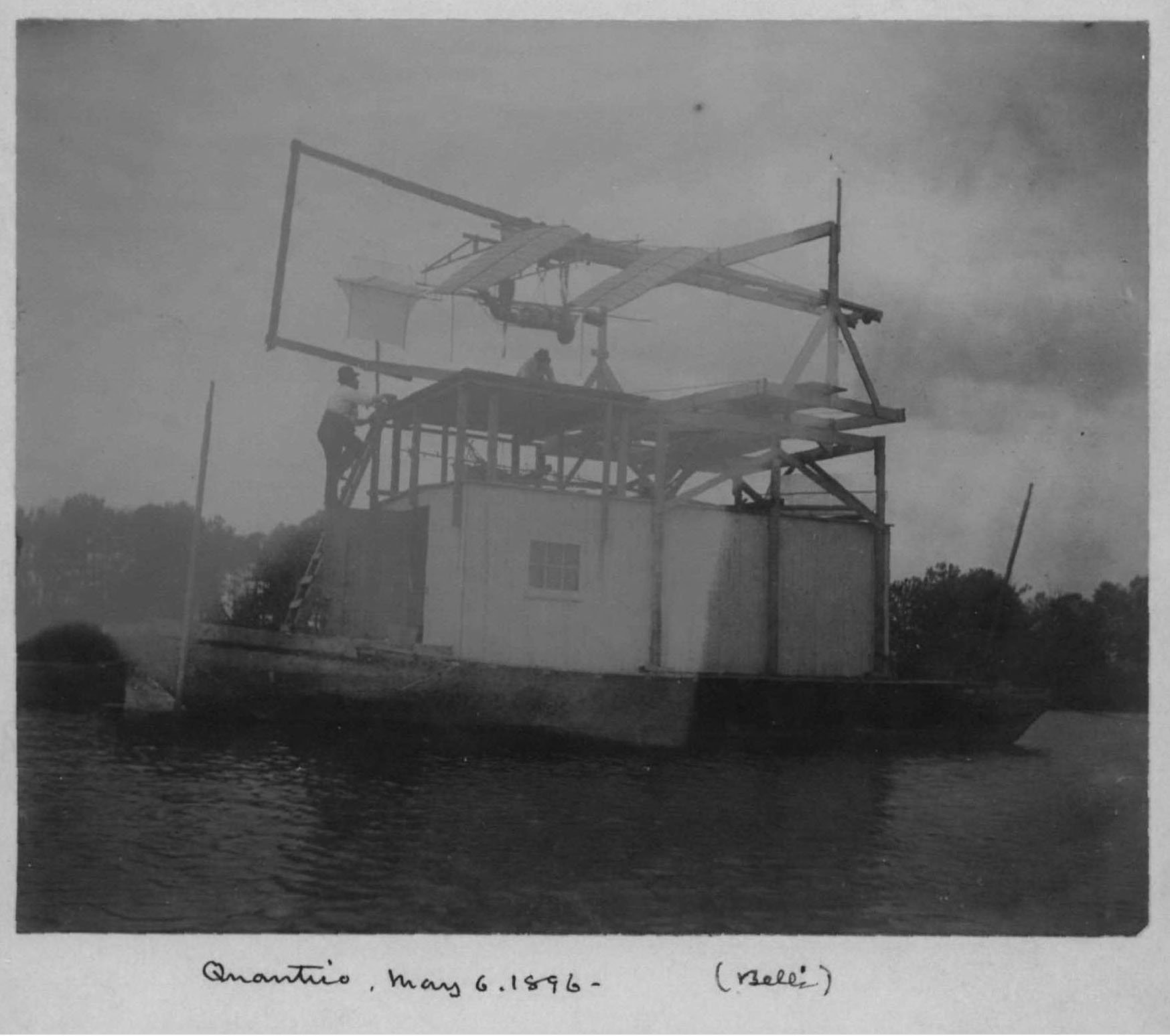
Bell’s Photograph #1 included the following notation in the Smithsonian file:

The struck note at the top of the notation highlights the disassembled parts of Aerodrome No. 6 on the roof of the houseboat, under the catapult, which were apparently placed there after its earlier failed test. The fuselage of the aerodrome rests beneath the rear of the catapult while a wing, standing on its end, is visible at the front. Curiously, however, no parts of Aerodrome No. 6 are present in Fowle Photograph #1.
Further evidencing F.E. Fowle’s position on Chopawamsic Island, Fowle Photographs #2 and #3 are taken from successive vantage points, each progressively further north and west of Fowle Photograph #1. The progression of Fowle photograph vantage points match the direction and distance of the Chopawamsic shoreline as Fowle moved from the southern end of the island (Photograph #1) to the center of the island (Photograph #3) to photograph the front of the houseboat shortly before launch. While the fuselage of Aerodrome No. 6 is not visible in Fowle Photographs #2 and #3, the vertically oriented wing is present below the front of the catapult in both.
The boat or platform from which Alexander Graham Bell took his photographs on the port side of the houseboat does not appear in Fowle’s first three photographs, in particular, in Photograph #3 from which angle it would have been visible if the photographs were taken at the same time. The absence of the disassembled Aerodrome No. 6 in Fowle’s Photograph #1 and Bell’s boat in Fowle’s Photographs #2 and #3 lead to the timeline illustrated in Exhibit B below. Exhibit B also includes the proposed timeline for Bell Photograph #3, which will be discussed later in the analysis.
Exhibit C - Pre-Launch Photograph Key Overlaid on “Path of Aerodrome Flights”, from Langley Memoir of Mechanical Flight, Plate 19.
Launch Photographs
At approximately 3:05 p.m., Aerodrome No. 5 was launched, and both Bell and Fowle captured the craft in its first second of flight from their respective vantage points. Bell’s Photograph #2, which is of significantly better quality, captures Aerodrome No. 5’s launch in stunning detail considering the distance to, and motion of, the craft. The photograph also gives the first glimpse of the western side of Chopawamsic Island, including the Ducking Club’s clubhouse visible through the trees, and two structures, likely boathouses or storage structures, to the far left. Aerodrome No. 6’s wing is still visible below the catapult as one of the engineers (either Mr. Reed or Maltby) hugs the support post as he watched the Aerodrome No. 5 make history.
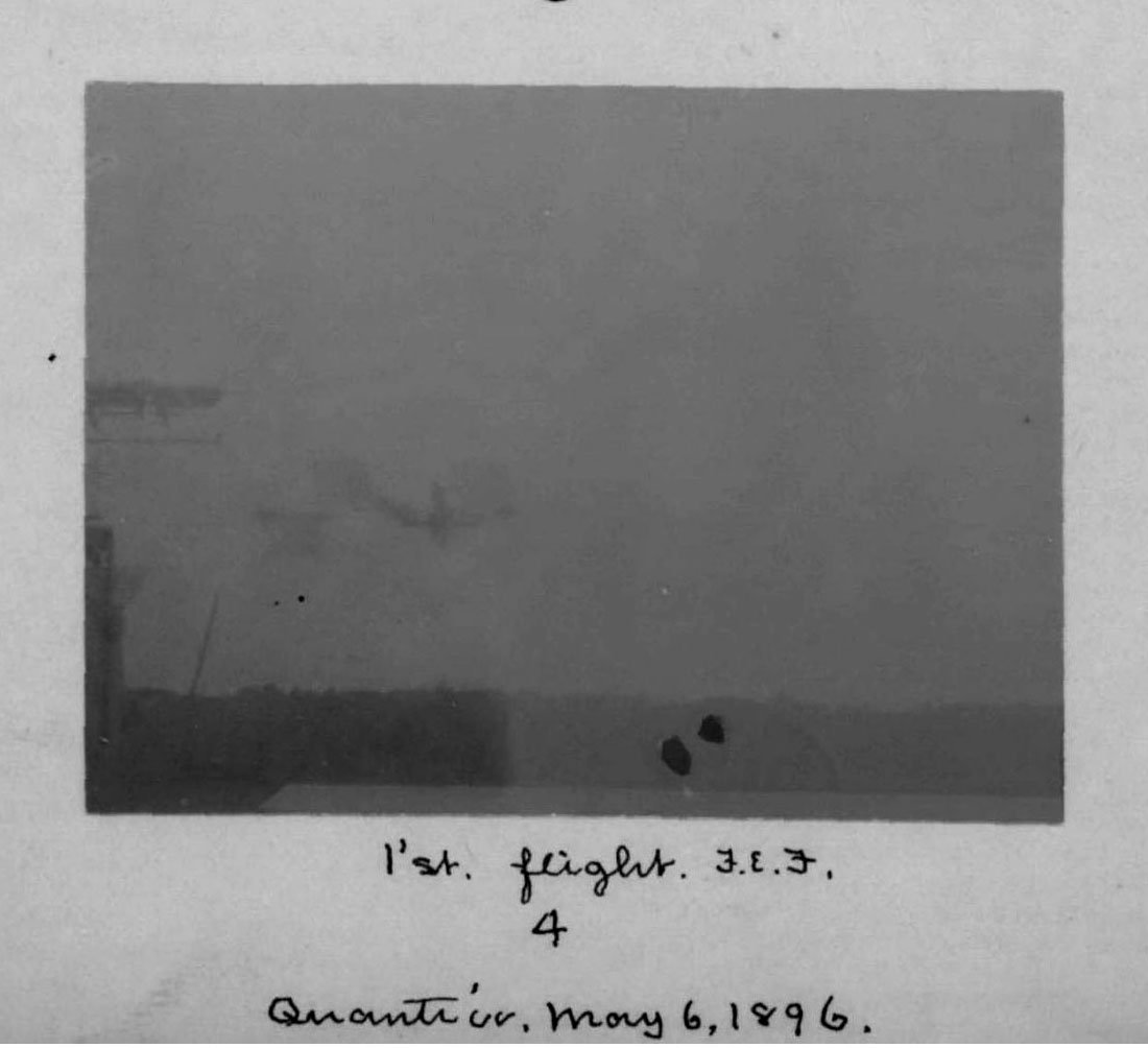
Fowle’s Photograph #4 was taken at the same instant from Chopawamsic Island. The front edge of the houseboat and the end of the launching track are visible on the left side of the image and the Stafford County mainland in the background. While the photograph is blurry it does confirm Langley’s account that Aerodrome No. 5 “descended three or four feet” “immediately after leaving the launching track.”
Annotated Launch Photos

Bell Photo #2 Annotated
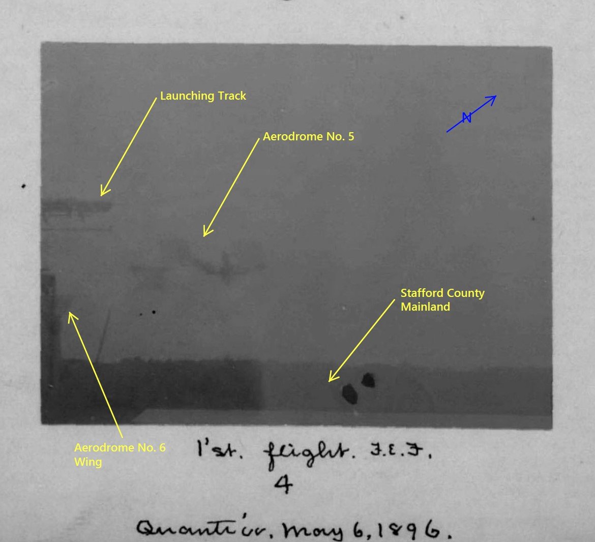
Fowle Photo #4 Annotated
Mid-Flight Photographs
The Smithsonian’s National Air and Space Museum online repository does not include any additional photographs of the aerodrome in flight taken by Alexander’s Graham Bell. Given the higher quality of Bell’s photographs, it is possible that his equipment setup may have made tracking and capturing the aerodrome in flight more difficult. Frederick E. Fowle, on the other hand, captured at least three, and likely four, images of Aerodrome No. 5’s first flight on May 6, 1896, starting with the previously discussed Fowle Photograph #4. The second, Fowle Photograph #6, shows the aerodrome in flight heading south between its first and second clockwise revolution. The third, Fowle Photograph #7, while underexposed and blurry, captured mankind’s most significant aeronautical achievement of the nineteenth century, a heavier-than-air craft soaring nearly 100’ in the air under its own power.
Annotated Fowle Mid-Flight Photos

Fowle Photo #4 Annotated

Fowle Photo #6 Annotated

Fowle Photo #7 Annotated
Fowle Mid-Flight Photos with Langley Memoir Plate Overlays
Overlaying the “Instantaneous Photograph of the Aerodrome at a Distance in the Air” (Vol. 27, No. 3, Pl. 22) from Langley Memoir on Mechanical Flight reveals that an enlarged version of Fowle Photograph #6 was used to create Plate 22. An enlarged and enhanced version of Fowle Photograph #7 appears as “Instantaneous Photograph of the Aerodrome at a Distance in the Air” (Vol. 27, No. 3, Plate 21) in Langley Memoir on Mechanical Flight. The fact that this photograph was used for Plate 21 is verified by overlaying Plate 21 on Photograph #7 as shown in XII below.

Fowle Photo #6 with Langley Memoir Plate 22 Overlay

Fowle Photo #7 with Langley Memoir Plate 21 Overlay
Exhibit D merges Fowle Photographs #4, #6, and #7 into a composite image using the Stafford County mainland treeline in each photograph for scale and location. The composite image conclusively shows that Fowle Photographs #4, #6, and #7 were all taken from the same general location on Chopawamsic Island and validates the May 6, 1896 flight path sketched in Langley Memoir on Mechanical Flight, Plate 19. The approximate flight path corresponding to the path shown on Plate 19 has been sketched added to the composite image.
Fowle Mid-Flight Photo Composite Annotated

Exhibit D – Composite Image Combining Fowle Photographs #4, #6, and #7
Using geometric principles and the known dimensions of Aerodrome No. 5 and distance and height to the aerodrome in Fowle Photograph #4 (based on measurements provided in Exhibit A), I’ve computed that Aerodrome No. 5 is approximately 450-500 feet from Fowle in Photograph #6. Further, this distance estimate can be used to estimate the elevation of Aerodrome No. 5, which is approximately 40 feet above the Potomac River in Fowle Photograph #6.
Using the method discussed above, I’ve computed that Aerodrome No. 5 is approximately 850-900 feet from Fowle in Photograph #7 at a elevation of approximately 85’ above the Potomac River, which is consistent with the 70-100’ estimates made by Langley’s team on May 6th. In addition, based on a total flight time of one minute thirty seconds, I estimate that Fowle Photograph #6 was taken at approximately T+40 seconds and Fowle Photograph #7 was taken at approximately T+60 seconds, shortly before the engine ran out of steam and began its descent.
Exhibit E provides Fowle’s estimated location from which he captured Photographs #4, #6, and #7, and the time sequence and direction of each photograph. Based on Langley’s firsthand account of the flight of Aerodrome No. 5, these photographs were all taken between 3:05 and 3:07 pm on May 6, 1896. The measured distance between Fowle’s estimated position and Aerodrome No. 5 measured on Exhibit E are within the distance range computed above.
Exhibit E – Post-Launch Photograph Key Overlaid on “Path of Aerodrome Flights”, from Langley Memoir of Mechanical Flight, Plate 19.
Post-Flight Photography
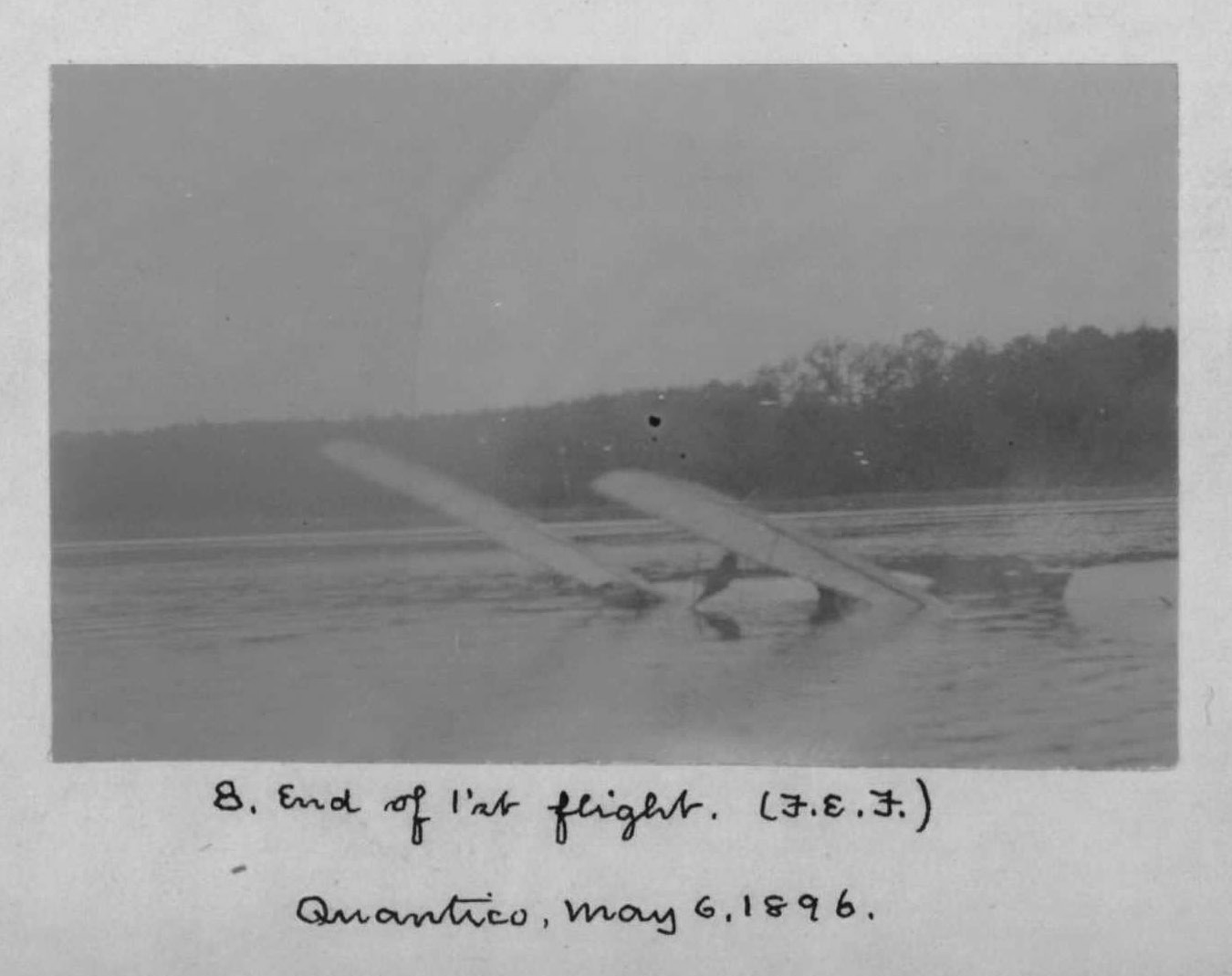
The final Fowle photograph of Aerodrome No. 5’s first flight shows the aerodrome partially submerged in the Potomac River where it landed after its one minute thirty second flight. According to Langley Memoir on Mechanical Flight, “The aerodrome was immediately recovered from the water and preparations made for a second test, the machine being launched again at 5:10 p.m.”
Fowle Photo #8
Missing Photograph #5
The Fowle photograph collection in the Smithsonian National Air and Space Museum Archives lists a total of 14 photographs, however, only 13 of the photos are scanned in the format above with handwritten labels. Photograph #5 is missing. However, the photograph below is included in the scanned file with no caption. It is possible that the photograph is the 5th photo taken by Fowle on May 6th. This close up view of Aerodrome No. 5 may have been taken between Photo #4 and Photo #6, at the point in which the aerodrome made its sharp 180 degree turn from northeast to southwest. However, without a label, I cannot confirm when this image was captured.
Possible Fowle Photograph #5
Bell’s Mystery Photograph #3
The identity of the subject of Bell Photograph #3 is unknown. One theory is that it is Alexander Graham Bell coming out of an outhouse near Quantico Junction. However, it is my hypothesis that the figure is Samuel Pierpont Langley standing on a dock on the southwestern side of Chopawamsic Island either before or after the famous launch of Aerodrome No. 5.
Bell accompanied Langley to Chopawamsic Island as a friend, scientist, and benefactor with a keen interest in aeronautics. He understood the importance of documenting experiments for posterity, to support patent claims, and garner investment capital. Bell Photograph #3 shares the same “Quantico – May 6, 1896 (Bell’s)” notation as Bell Photographs #1 and #2, which are known to have been taken by Bell himself at Chopawamsic Island around 3:00 pm on May 6, 1896. If Photograph #3 was taken by Bell as well, he wouldn’t have been the subject of his own photograph. Capturing Langley before the start of the flight, or immediately afterwards, would make perfect sense.
Bell Photograph #3
According to Langley Memoir on Mechanical Flight, Langley and Bell arrived in Quantico on May 5th and continued experiments into the evening of May 6th. Langley utilized the island as his base of operations during his experiments and was accommodated there overnight, making it probable that the two were on Chopawamsic Island for the entirety of May 6th. Further evidence that Bell Photograph #3 was taken on the island is the appearance of water behind the shallow wood line behind the subject. It is unlikely that an outhouse was in use on Chopawamsic Island in 1896. Most homes built in the late nineteenth century had indoor plumbing, and a “handsome clubhouse” hosting presidents, statesmen, and men of science would certainly have such an accommodation. In addition, the structure appears to be built on top of an elevated platform; unusual for an outhouse, which would typically be built over a pit. The side of the structure facing the photographer is bathed in sunlight suggesting that if it was taken at approximately 3:00 pm on May 6th, as were Photographs #1 and #2, it was located on the southwestern side of the island and facing southwest based on the computed location of the sun at that date and time.
In Langley’s firsthand account published in The New Flying Machine in 1897, he stated that he “watched it from the shore,” which surely meant Chopawamsic Island and not the mainland, located over 1,500 feet away. From the southwestern side of the island Langley would have had an ideal vantage point directly in front of Aerodrome No. 5 from which to communicate with the engineers on the houseboat and observe the launch, in particularly any mechanical failures that may occur such as the one that plagued Aerodrome No. 6 earlier in the day.
The figure is dressed in a suit and hat, as either Langley or Bell would have been on that day and appears to be holding a notebook and a flag, which could have been a device used by Langley to signal “Ready” or “Launch” to Mr. Reed and Mr. Maltby on the houseboat. While the subject of the photo does resemble contemporary photographs of Alexander Graham Bell, it also resembles photographs of Langley shortly thereafter. Exhibit F compares a photo of Langley taken in 1903 at the failed launch of Aerodrome ‘A’ and a circa 1900 portrait of Langley seated to the subject of Bell Photograph #3.
Finally, given the importance and limited number of photographs of this event, it’s difficult to imagine Bell wasting a photographic negative on a pedestrian subject or providing such a photograph to the Smithsonian for posterity. For these reasons, I believe that Bell Photograph #3 is of Samuel Pierpont Langley on a southwest facing dock on Chopawamsic Island, immediately prior to the launch of Aerodrome No. 5. The estimated location of the subject of Bell Photograph #3 is identified with a green dot on Exhibit E.
Exhibit F – Comparative Photographs of Samuel Pierpont Langley Next to Bell Photograph Subject